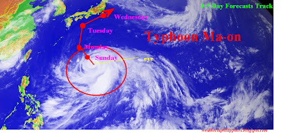
Issued: 11:30A.M PhST 07/16/2011
Typhoon Ma-on weakens slightly due to an area of unfavorable environment (which includes moderate vertical wind shear). Latest satellite imagery depicts a 27 km. eye surrounded by by a near complete eye wall with a break northwest of the system. As of this moment, Typhoon Ma-on is currently influencing the track and intensity of Tropical Depression Tokage (Hanna/09W) with Fujiwara effect observed. This weak system is moving ENE and being absorbed into the southern rain bands of Typhoon Ma-on. However, Typhoon Ma-on is expected to regains Category 4 status (Super Typhoon) within the next 12-24 hours because of the favorable environment.
Typhoon Ma-on (08W) | |
Saffir-Simpson Typhoon Scale | Category 3 |
Location | 21.3N 138.3E |
Distance | 1639 km. South of Tokyo, Japan |
Maximum Sustained Winds | 195 kph |
Gustiness Winds | 241 kph |
Movement | WNW @ 17 kph |
Towards | Southern Japan |
Maximum Sea Wave Height | 32 feet |
Minimum Sea Level Pressure | 945 mb |

Walang komento:
Mag-post ng isang Komento