06/03/2012 06:00 AM PhST Extended Computer Models issued by ECMWF shows a possible Tropical Cyclone Formation along the South China Sea within June 08-12, 2012.

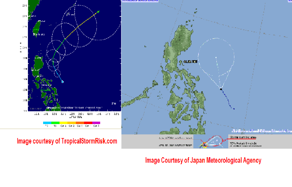
06/01/2012 06:30 AM PhST Latest Forecast Tracks for Tropical Depression AMBO/04W issued by different weather agencies.

05/31/2012 05:00 PM PhST Tropical Disturbance 95W consolidates more strength while over the Eastern Philippine Sea. 95W just upgraded as a Tropical Depression by the Japan Meteorological Agency.

12/16/2011 11 A.M PhT Troical Storm Washi has slightly intensified while moving towards Surigao del Sur-Davao Oriental area. Here are the different latest informations about the said active cyclone.

12/15/2011 2 P.M PhT Bad weather conditions is possible along the Northeastern Mindanao tomorrow afternoon as T.S moves closer towards the area.

07-08-2011 6 A.M PhST European Center for Medium Range Weather Forecasts Model issued yesterday late afternoon (PhST). Tropical Cyclone Formation is possible between July 13-July 17, 2011 along Western Pacific Ocean (thousand km. East of Luzon). Latest model forecasts that this active system will not become a threat in any parts of the country.
07-07-2011 9 A.M PhST Tropical Disturbance 94W is currently located 23.9N 125.7E, about 333.35 km. South-Southwest of Kadena AFB. Latest satellite imagery depicts a weak LLCC. Maximum sustained wind winds remains at 27 kph with a gustiness winds of 37 kph. Minimum sea level pressure is estimates to be at 1002 mb. TCF as of this moment is still low.
07-04-2011 8 A.M PhST Tropical Disturbance 94W now over 600 km. ENE of Virac Catanduanes with a maximum sustained winds of 28 kph and gustiness of 37 kph. It has a medium chances as computer models forecasts this system to develop by the end and early next week (July 07-14, 2011) near Eastern Luzon-Taiwan area. This system is currently embedded in a broad Monsoon Trough within the active ITCZ.

06/01/2012 06:30 AM PhST Latest Forecast Tracks for Tropical Depression AMBO/04W issued by different weather agencies.
05/31/2012 05:00 PM PhST Tropical Disturbance 95W consolidates more strength while over the Eastern Philippine Sea. 95W just upgraded as a Tropical Depression by the Japan Meteorological Agency.

12/16/2011 11 A.M PhT Troical Storm Washi has slightly intensified while moving towards Surigao del Sur-Davao Oriental area. Here are the different latest informations about the said active cyclone.

12/15/2011 2 P.M PhT Bad weather conditions is possible along the Northeastern Mindanao tomorrow afternoon as T.S moves closer towards the area.

07-08-2011 6 A.M PhST European Center for Medium Range Weather Forecasts Model issued yesterday late afternoon (PhST). Tropical Cyclone Formation is possible between July 13-July 17, 2011 along Western Pacific Ocean (thousand km. East of Luzon). Latest model forecasts that this active system will not become a threat in any parts of the country.
07-07-2011 9 A.M PhST Tropical Disturbance 94W is currently located 23.9N 125.7E, about 333.35 km. South-Southwest of Kadena AFB. Latest satellite imagery depicts a weak LLCC. Maximum sustained wind winds remains at 27 kph with a gustiness winds of 37 kph. Minimum sea level pressure is estimates to be at 1002 mb. TCF as of this moment is still low.
07-04-2011 8 A.M PhST Tropical Disturbance 94W now over 600 km. ENE of Virac Catanduanes with a maximum sustained winds of 28 kph and gustiness of 37 kph. It has a medium chances as computer models forecasts this system to develop by the end and early next week (July 07-14, 2011) near Eastern Luzon-Taiwan area. This system is currently embedded in a broad Monsoon Trough within the active ITCZ.
07-03-2011 5 P.M PhST Tropical Disturbance 94W consolidates more strength for the past 6 hours. Currently located about 940 km. East of Surigao City and moving northwestward slowly. Newly developed Tropical Disturbance 96W near 94W maybe absorbed by the strong system which is embedded in the active ITCZ. Tropical Disturbance 95W not expected to intensify.